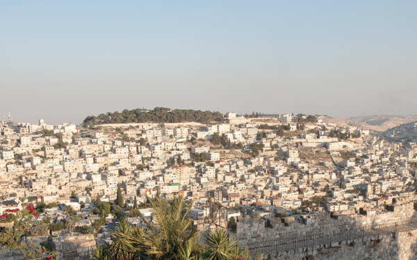
Jerusalem – the city that witnessed the rise and fall of empires – represents religious interest for more than 3.5 billion people, more than 54 percent of the world’s population. It has a long and bloody history mixed with political controversies, and while some of the world’s cities may identify one or maybe two historical critical points during their existence, Jerusalem seems to have an endless number of them.
Soon after the occupation of East Jerusalem in 1967, the Israeli government illegally redrew the city’s municipal boundary, increasing its area from 6.5 km2 to 71 km2 and including areas from 28 surrounding Palestinian villages. Consecutive Israeli governments encouraged and supported, through every possible means, the transformation of Jerusalem into a city with a distinctly Jewish identity in order to stake their hold over the city. Scores of Jewish-only settlements were built in the city and on its outskirts, forcing new realities on the ground.
Israel annexed to Jerusalem only the sparsely populated parts of other Palestinian governorates and excluded the highly populated Palestinian neighborhoods, including areas identified in the UN proposed plan to be part of the “Corpus Separatum” status, which meant that Jerusalem would have been placed under the custody of an international body because of its religious significance for the three monotheistic faiths.
From this point onwards, Israel embarked on a campaign to manipulate the demographic and geographical realities of the city in order to strengthen its claim and sovereignty over Jerusalem. To achieve this goal, consecutive Israeli governments improvised several laws to increase the number of Jews and reduce the number of Palestinians living in the city, expunge its Arabic culture and history, and evacuate the city of its Palestinian inhabitants.
To this end there was a sequence of steps that helped Judaize the city, including land confiscation, restrictions on land use, the construction of settlements, bypass roads, and the Segregation Wall, and a ban on Palestinian construction. These acts have mutated the city’s landscape and created new perceptions of the city with the intention to push the Palestinians “voluntarily” out of the city and ultimately “de-Palestinize” and “de-characterize” Jerusalem.
Housing and restrictions on development
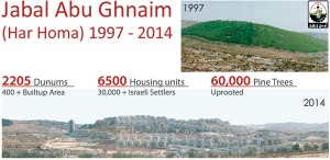
Planning and zoning regulations of the Israeli Municipality of Jerusalem are, according to all international standards, racist. The principal goal of these regulations is to halt East Jerusalem’s urban development. The classification of 22 percent of East Jerusalem land as “green area” (protected landscape areas), and 30 percent “without planning areas” (not included within municipal or local government land-use planning) has served to hinder Palestinian urban development plans in the city. This turned out to be part of the deceptive and manipulative Israeli overall plan to keep Palestinians from accessing and using the land, and to give the Israelis time to conclude procedures to take over land for use in settlement building. Two particular Israeli settlements – Rekhes Shufat (Ramat Shlomo), established on confiscated lands from the Palestinian community of Shu’afat, located north of Jerusalem; and Har Homa, which is the Jewish settlement name for Abu Ghnaim Forest Mountain, northeast of Bethlehem – were subjected to such a procedure as the locations were first classified as “green areas” and later rezoned as “building areas.”
Moreover, different building rules and regulations apply, depending on whether the sites in question are in Palestinian areas or Israeli areas. For example, Palestinians were allowed only to build upwards; in other words, they could only construct additional stories to their buildings rather than build additions to already existing buildings or new buildings altogether. But even this regulation was eventually narrowed, as the municipality restricted the number of stories allowed per building. The percentage of land allowed to build on is also strictly controlled, and ranges between 35 percent and 70 percent. In contrast, no such regulations exist for settlements. Moreover, the Israeli government regularly manipulates laws and zoning areas by reclassifying “green areas” to high-density housing areas.
On May 9, 2013, the Israeli government advanced a nationwide housing plan, which was set to alleviate building restrictions and enable construction in green areas. This was not the first time such plans were put into action. It happened before when Israel re-zoned locations such as the Har Homa and Ramat Shlomo settlements. This is a direct manipulation of the city’s demography, giving local planning and building committees the power to approve large housing construction projects on private land and evacuating inhabitants. This can be done without the approval of the Interior Ministry’s planning committee for open areas and farming land, and means that the committees can decide which of the public land areas classified as “green areas” may be rezoned for construction. Other locations – owned by Palestinians – remain under such status until a time when its ownership changes or is manipulated to meet the interest of the Jewish population in the city.
This unfortunate reality is supported by the fact that the bulk of Palestinian lands had become off limits to Palestinians following the Israeli occupation of the city and the unilateral designation of the land in Jerusalem as 22 percent “green area,” not including some 30 percent of the land within the planning system, thus making the land unusable for Palestinians. This reality is driving thousands of Palestinians out of the city to cope with the population growth outside the illegally drawn city boundary, ultimately manipulating the city’s demography and the possible future negotiations over the fate of the city.
The Israeli Local Committee at the Jerusalem Municipality will discuss Town Planning Scheme 10188 regarding Ya’ar Hashalom (Peace Forest), located between Talpiot settlement and the Palestinian community. Abu Tur is regularly used by the Elad settler organization for tours and sports activities. During previous years, Elad illegally fenced off an area and added trailers to serve as offices, storage spaces, and group lecture rooms. The Jewish National Fund (JNF) is involved in advancing the plan in order to legalize the fence and trailers by designating the Elad-controlled area as a tourism center. Ya’ar Hashalom is one of a chain of national parks designed to solidify Israeli control over the Old City Basin. In the early nineties of the last century, the Israeli Municipality of Jerusalem started to use the term “Holy Basin” in reference to the entire area of the Old City of Jerusalem and wide sectors of its outskirts, which include areas of Al-Sheikh Jarrah and Wadi al-Joz to the north, Al-Tur to the east, and Silwan to the south. The Holy Basin is intended to enforce the Jewish character and existence in that area as the municipality intends to establish a biblical project (Ir David or the City of David) beneath Al-Aqsa Mosque and on the lands of Al-Bustan neighborhood of the proximate Silwan town and parts of the Islamic Quarter in the Old City of Jerusalem.
Jerusalem (2000) Master Plan
In September 2004, Jerusalem Mayor Uri Lupolianski announced the preparation of a Jerusalem master plan, with a projected duration to the year 2020. Its main objective is to “reinforce the status of Jerusalem and ensure its continuous development as the capital of Israel and the center for the Jewish people and a sacred city for all religions.” The master plan specifies the need for the construction of 43,000 new housing units for the Palestinians living in the city. Yet the plan aims for the development of only 2,300 dunums by the year 2020 in East Jerusalem, which will allow for the construction of only 9,200 apartments.
Greater Jerusalem
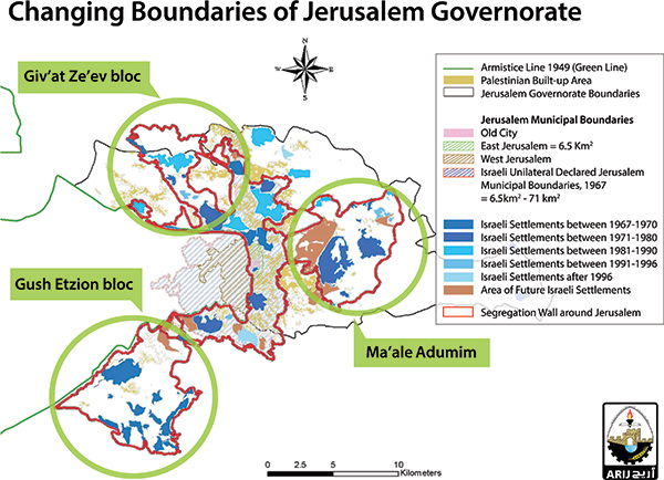
“Greater Jerusalem” gained currency as a concept during the late 1970s/early 1980s, when the Israeli consecutive governments worked to consolidate the belt of settlements constructed outside the Israeli-defined Jerusalem municipal boundary and particularly outside the new definition of East Jerusalem, according to the Israeli occupation, an area expanded from 6.5 km2 to 71 km2. This was the first unilateral and illegal expansion of East Jerusalem.
The belt of settlements around the newly defined East Jerusalem intended to increase the Jewish existence geographically and demographically and, more significantly, to cut the territorial continuity of East Jerusalem with its natural environment and the rest of the West Bank. Today, the belt of settlements consists of three main blocs, encapsulated with Jerusalem by the Segregation Wall, which paves the way for the second unilateral and illegal expansion of East Jerusalem.
* The Giv’at Ze’ev bloc – north of Jerusalem (Population 16,000+ settlers, area 12 km2)
* The Ma’ale Adumim bloc – east of Jerusalem (Population 51,000+ settlers, area 72.5 km2)
* The Gush Etzion bloc – southwest of Jerusalem (Population 62,000+ settlers, area 73 km2)
The consequences of Greater Jerusalem fall into two correlating categories: First, geographical, as the area will stretch to exceed the current area (71 km2) of East Jerusalem by 146 percent, and the additional 175 km2 that consist of 157.5 km2 of settlement-blocs area and additional areas of 17.5 km2, located north of Bethlehem, and the J2 areas of Jerusalem (areas not included within the illegal Israeli municipal boundary of Jerusalem). Second, demographical change, which works simultaneously with the geographic factor to further consolidate Greater Jerusalem. The Palestinian Central Bureau of Statistics (PCBS) indicates that by the year 2020 Palestinian Jerusalemites will overwhelm the city population.
The second illegal Israeli expansion of the Jerusalem boundary is intended to combat the anticipated Palestinian population dominance by adding the settler-bloc population of 127,000, in addition to the extensive increase due to planned construction in Jerusalem settlements (20,000 housing units to accommodate some 80,000 Jewish settlers) and the influx of Jewish immigrants to the occupied city.
At the same time, Israel will exclude (and ultimately revoke) the residency of Palestinian Jerusalemites who live in neighborhoods that, because of the Segregation Wall, are no longer included within the boundaries of Jerusalem; hence Kufer Aqab (population 20,000) and Shufat Refugee Camp (population 35,000).
Ultimately, this will work to maintain what Israel seeks to pretense as reality; dropping the current Palestinian population ratio of 37 percent to just about 13 percent, while increasing the Jewish population ratio to 87 percent, jumping from the current 63 percent; believing that this would impact and steer future negotiations over the fate of the city.
 Currently, the population density in Jerusalem reflects the Israeli restrictions imposed on Palestinian development of their communities to cope with the population growth; so while the population density of Jerusalemites in Palestinian built-up areas outside the Israeli-defined Jerusalem municipal boundary stands at 7,633 individuals per square meter, it jumps to 18,931 individuals per square meter within the Israeli-defined Jerusalem municipal boundary.
Israel’s future development plans
Israeli development plans in Jerusalem have not decreased at any point since the beginning of the Israeli-Palestinian “peace” process. In fact, the number of Israeli settlers in occupied East Jerusalem has increased by 111 percent since the peace process was launched back in 1993, from 140,000 settlers then to more than 296,801 today.
To this day, Israel continues to violate Palestinian rights to develop their own communities, and relentlessly drives Palestinians out of the city only to make room for more Israeli-Jewish new residents to win the demographic battle of the city. The following are the Israeli so-called development plans in occupied East Jerusalem, which are intended to further fortify the occupation grip over the occupied city. In 2005, the planning committee of the Israeli municipality of Jerusalem authorized the demolition of Shepherd Hotel, located in Karem Al-Mufti in the Palestinian neighborhood of Al-Sheikh Jarrah, and sanctioned plans to build 350 housing units, a synagogue, a kindergarten, and a clinic to serve Jewish residents.
In 1998, the Israeli municipality of Jerusalem refused to endorse the Palestinian neighborhood Master Plan for Ras Al ‘Amoud, in return; Ma’ale Hazeitim settlement was sanctioned where it stands, with 133 housing units, a commercial center, a synagogue, a kindergarten, and a clinic. Since 1991 Jewish settlers from Ir David Settlement in Silwan seized more than 40 Palestinian houses by force in Wadi Hilwa. In May 2005, the Israeli municipality of Jerusalem slated for demolition 88 houses (home to more than 1,000 Palestinian residents) in Al-Bustan neighborhood. In Jabal al-Mukaber, the Israeli local committee for planning and building approved the settlement called Nof Zion on an area of 48 dunums. It includes the construction of 100 housing units, a hotel (with 150 rooms), and a kindergarten. The E1 Plan, to be implemented on 12,500 dunums of land confiscated from the Palestinian localities of Al-Eizzariya and Abu Dis, will deny these localities their remaining expansion territory to cope with population growth. On the other hand it will fortify the Jewish presence in the area with the E1 Plan, pending 3,900 new housing units, but more importantly it will create corporal links between Ma’ale Adumim settlement bloc and Israeli settlements in Jerusalem (Pisgat Ze’ev, Pisgat Omer, Neve Ya’acov, and French Hill). Moreover the E1 Plan will constitute a physical barrier that will cut off Jerusalem from the West Bank and break the geographical contiguity of the West Bank into two separate entities, one to the north of Jerusalem and the other to the south.
Jerusalem and the segregation plan
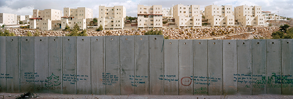
One of the most controversial areas being targeted by the Israeli Segregation Wall in the occupied West Bank territory is East Jerusalem, the part of the city that the Palestinians recognize as the capital of their future state. Israel is upholding its illegal claim on this part of the occupied city in accordance with the assertion that Jerusalem is the “unified” and “sovereign” Israeli capital. When Israel sought to build the Wall in the West Bank, it intended to geographically separate East Jerusalem from its natural environment of the West Bank. In addition, Israel calculated to manipulate the demographic balance of the city in favor of the Jewish population. The anticipated Wall that is set to encapsulate the city runs for 227 km, 129 km (57 percent) of which already exist, with 51 km of cement partitions and 78 km of fence. Moreover, 76 km (33 percent) of the Wall are still in the planning phase, and 22 km (10 percent) are currently under construction. Once completed, the Segregation Wall will serve much more than its purported purpose (security). Many Israeli officials insinuated that the Wall would eventually act as a border between “Israel” and the Palestinian state. Hence, it would also identify the new municipal boundary of Jerusalem, thus confirming that Kufer Aqab (population 20,000) and Shufat Refugee Camp (population 35,000) would no longer be part of what would most probably be the new Israeli municipal boundary of occupied East Jerusalem.
Terminals in the Jerusalem governorate
Israel draws the new gates of Jerusalem
When Israel redrew the boundary of occupied East Jerusalem in 1967, it intended to induce procedures to maintain a Jewish majority and to win the demographic battle over the city. Over the years, Israel has constructed dozens of settlements in and around the occupied city to accommodate hundreds of thousands of Jewish inhabitants. Israel has also restricted the development and expansion of Palestinian neighborhoods and adopted property tax procedures to squeeze Palestinians out of the city.
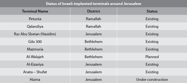
Today, with plans of the Segregation Wall in play to isolate Occupied East Jerusalem, Israel is making sure to exclude as many Palestinian Jerusalemites from the city for the last time. To achieve that purpose, Israel has isolated Jerusalem from the West Bank, restricting access to it with nine checkpoints, which are in reality terminals that control movement to and from the city.
These terminals are distributed according to the Israeli vision of Greater Jerusalem, which encompasses lands from the Bethlehem and Ramallah districts. The following table shows the location of each terminal and its status.
In the event that Israel completes its construction of the Segregation Wall around East Jerusalem, the Palestinian communities in the Jerusalem governorate would be surrounded by a complex of walls, settlements, and roads that would eliminate any future possibility for the Palestinian communities to expand, thus jeopardizing sustainable development. The Applied Research Institute-Jerusalem (ARIJ) asserts that it is imperative that Israel comply with international legitimacy, laws, and UN resolutions, including Security Council Resolution 452 (1979), which calls upon “the Government and people of Israel to cease, on an urgent basis, the establishment, construction and planning of settlements in the Arab territories occupied since 1967, including Jerusalem,” and to abide by Security Council Resolution 446 (1979), which “[d]etermines that the policy and practices of Israel in establishing settlements in the Palestinian and other Arab territories occupied since 1967 have no legal validity and constitute a serious obstruction to achieving a comprehensive, just, and lasting peace in the Middle East.”
» Dr. Jad Isaac is the director general of the Applied Research Institute – Jerusalem (ARIJ). He is the former dean of science at Bethlehem University. He headed the Palestinian delegation for the environmental working group in the multilateral talks and is an adviser to the Palestinian negotiating team on final-status issues.
» Suhail Khalilieh is the head of the Settlements Monitoring Department at ARIJ. He is a political analyst and an expert on Israeli settlements and policies practiced by the Israeli army in the occupied Palestinian territory.

