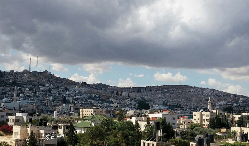
Jenin is located at the southern edge of Marj Ibn Amer, about 43 kilometers north of Nablus, on the ancient trade road from Nablus through the Arraba plain or the Plain of Sanur to Wadi Bal’ama and across the plain of Marj Ibn Amer and Lajjun to Haifa. It is situated at an altitude of about 100 to 250 meters above sea level. The plain is one of the most fertile areas in Palestine, and it was a main source of agricultural subsistence throughout history for the communities that settled there.
Ancient Jenin is identified with Tell Jenin located in the center of the town. Jenin was mentioned as Gina in the Amarna Letters in the fourteenth century BC, and as Qena on the Papyrus Anastasi from the reign of Thutmose III. In the Bible, Jenin is referred to as En Gannim.
The other main chapter in the early history of Jenin, during the Middle Bronze Age and Late Bronze Age, is represented at Khirbet Bal’ama, located at the southern entrance of Jenin, approximately two kilometers south of Tell Jenin in the main center of the city. The site was a fortified Canaanite city that occupied a strategic position along the historical route of Wadi Bal’ama that linked the Arraba Plain with Marj Ibn Amer. The site is identified with ancient Ibleam, which was mentioned in the Egyptian Royal Archive in the fifteenth century BC. During the classical period it was known as Belmont, and in the medieval period as Castellum Beleismum.
Archaeological excavations carried out at Tell Jenin fixed the cultural history of the town and showed that Jenin was established as a small village during the Neolithic period (8000 BC). After a period of abandonment, the site was re-inhabited during the Early Bronze Age (3300–2900 BC). It was a small town indicated by mud brick houses, plastered surfaces, hearths, and domestic activities. At the end of the Early Bronze Age the site was abandoned, and the center of the city was moved to Karem Jenin in the Middle Bronze Age II, and to the nearby sites of Khirbet Bal’ama and Khirbet en-Najjar. In 1998, a tomb was excavated by the Palestinian Department of Antiquities on the Sikka road, between Tell Jenin and Khirbet Bal’ama with a whole assemblage of Early Bronze Age I pottery. Life resumed in the town during the Late Bronze Age and the Early Iron Age. Remains of this period are represented by domestic architecture, courtyards, walls, and plastered basins. Remains from tombs of the Late Bronze Age and Iron Age were recovered in a series of tombs in the cemetery southwest of Khirbet Bala’ma.
The excavations at Khirbet Bal’ama recovered evidence from the Bronze Age, the Iron Age, and the Persian, Hellenistic, Roman, Umayyad, Crusader/Ayyubid, Mamluk, and Ottoman periods. It led to the recovery of the ancient water system, the means by which the inhabitants of the ancient site accessed the Bir As-Sinjil Spring at the base of the mound. It was designed to be used primarily in times of war and siege.
The tunnel consists of three parts: the archway at the lowest entrance, the rock-cut tunnel going upwards to the west, and the unfinished upper passage. The excavation uncovered evidence from the Bronze Age, the Iron Age, and the Persian, Hellenistic, Roman, Umayyad, Crusader/Ayyubid, Mamluk, and Ottoman periods.
In the classical sources, Jenin was known as Ginea, as mentioned by Josephus in the first century AD. The site of Tell Jenin was occupied intensively during the early Byzantine period, as indicated by houses, silos, and courtyards. Five kilometers to the west of Jenin lay the village of Burqin, associated with the tradition of the ten lepers who were miraculously healed by Jesus Christ, according to the New Testament. The church was dedicated to Saint George (Al-Khader), a popular saint for both Christians and Muslims. The first church was in a cave, which was originally a Roman cistern. The cave and the church were identified as remains of the Byzantine period. In the second phase, a church was built in front of the cave, between the sixth and the ninth centuries. It was described in documents from the Crusader and Ottoman periods. The present church consists of the cave, the main hall, and the nave. It was rebuilt during the eighteenth century AD. In 1997 and 2005, of series of restorations was carried out in the church.
♦ Palestinian Dishes
› Sumac
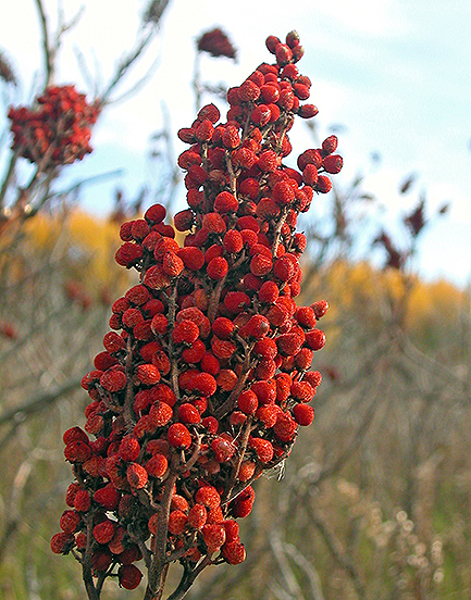
Sumac is a shrub that can reach a height of one to ten meters. The leaves are spirally arranged and are usually pinnately compound, though some species have trifoliate or simple leaves. The flowers are in dense panicles or spikes that are five to thirty centimeters long, each flower very small and either greenish, creamy white, or red, with five petals. The fruits form dense clusters of reddish drupes called sumac bobs. The dried drupes of some species are ground to produce a tangy crimson spice. Sumac propagates both by seed (spread by birds and other animals through their droppings), and by new shoots from rhizomes, forming large clonal colonies.
Sumac also happens to be one of Palestine’s unique spices. It is used in traditional dishes from salads, such as fattoush, to the main course, such as musakhan, and gives them a fresh, citrusy flavor.
Early Arab sources use the name Jenin. In the Umayyad period, Jenin was part of Jund Filastin. Remains were found from the Abbasid period in Tell Jenin.
During the Crusader period the city was named Grand Grin. A church was described at the end of the fifteenth century in the vicinity of the old town. A castle was built on the top of Khirbet Bal’ama to guard the historic pass of Wadi Bal’ama, which was apparently destroyed by Salah ed-Din after the Hattin battle in 1187 AD.
Medieval Arab sources refer to the city as Jenin. Yaqut Al-Hamawi (1179–1229) described it as a small, pleasant town located between Nablus and Beisan. The center of Jenin moved one kilometer to the east, on the western slope of Karem Jenin, in the place of the present old town of Jenin. Today’s old city, with its quarters and souqs, represents the Ottoman town of Jenin. Among the spectacular buildings of this period stands the Mosque of Fatima Khatoun at the foot of the old town and the school of Fatima Khatoun east of the mosque. The mosque was built in 1566 AD. At the end of the sixteenth century, Jenin was mentioned in the Ottoman tax register (dafters) as a small town. Remains of ancient aqueducts for irrigation of the fields in the plain are still seen in the northern part of the city.
Today, Jenin is a picturesque town that is built on the slopes of a hill and surrounded by gardens of olive, fig, and citrus trees. It is distinguished by its agriculture, producing an abundance of fruits and vegetables; and at one time it was famous for its watermelon. Jenin is located on the main tourist route from Bethlehem, via Jerusalem, Nablus, and Nazareth. During the last two decades Jenin witnessed the growth of internal tourism, especially Palestinians inside the Green Line, and family and school trips from various parts of the Palestinian areas. The ancient water tunnel system at the entrance of Jenin was rehabilitated as an archeological park and is now open to the public.