
The Jordan River is an international and transboundary watercourse with a common basin that is shared by five riparian nations: by Lebanese and Syrians in the upstream headwaters, by Israeli (on the territory of Historical Palestine) in the midstream position, and by Jordanians and Palestinians downstream on the East and West Banks of the deeply incised Rift Valley, ending in the Dead Sea. This brief overview introduces the different riparian contributions to the common watercourse: under natural flow conditions (before human abstractions) and with the current pattern of starkly asymmetric distribution in utilization.
The Jordan River is fed mainly by deep groundwater sources that emerge as springs and are fed by the large amounts of rain and snowfall on the more than 3,000-meter-high mountains of the Lebanon and especially the Anti-Lebanon mountain ranges. Three main spring groups – Hasbani, Banias, and Liddan – are commonly considered to form the source of the Jordan River.
The northernmost Hasbani Spring emerges in southern Lebanon, where it forms the Hasbani River that pours southwards into Historical Palestine (today, Israel); its last kilometers are complemented by the Wazzani Spring, still on Lebanese territory. Hasbani (and Wazzani) springs and river have an average flow volume of 161 million cubic meters per year (mcm/yr) under natural conditions.
Banias Spring emerges from the outcrops of the basalt aquifer in the foothills of the Syrian Golan, which has been occupied since 1967 and illegally annexed by Israel in 1981. (No nation on Earth recognizes this illegal annexation, except for Mr. Donald Trump, currently occupying the White House, his son-in-law, Jared Kushner, and his ambassador, the recently titled “third Israeli prime minister” David Friedman – all of whom are also known as the “honest brokers” of the Deal of the Century). The Banias Spring forms a creek that gushes forward dramatically and contributes another 149 mcm/yr to the upstream part of the upper Jordan River.
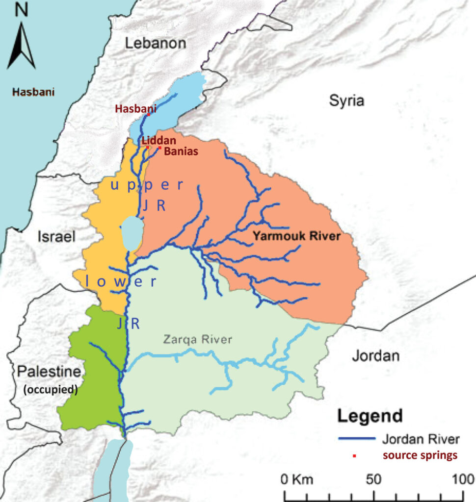
Most important are the Liddan Springs at Tall al-Qadi, a small hill in the northernmost Jordan Valley in Historical Palestine, only a few hundred meters away from the border with Syria (now the annexed Golan). They contribute over 260 mcm/yr of natural inflow into the Jordan River, thus forming the single-largest component of the upper Jordan River. This enormous spring flow is of course not generated within the few dozen meters of Israeli territory but comes from a very deeply buried Jurassic aquifer, which extends up to the high mountain range of the Anti-Lebanon, in a very large Lebanese and especially Syrian sub-basin, which reaches up almost to Damascus. Here, the Jurassic limestone series are exposed to rain and snowfall at the surface and recharged with groundwater that trickles into the craggy, karstified mountain rocks. This in turn means that not one drop of the water that is issued on Israeli territory in the Liddan Springs originates in Israel – it is all the Syrian and Lebanese recharged groundwater’s contribution to the Jordan River. This true nature of the riparian contributions and their origins is overlooked in most of the literature – as well as in the well-known Johnston Plan*1 (see below).
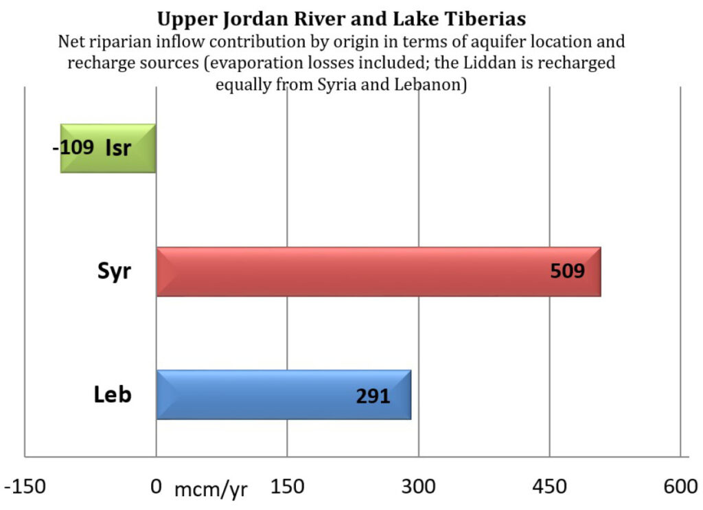
Moreover, the northern part of the upper Jordan River has to pass the swamps and wetlands of the Huleh marches, in which a lot of water (100 mcm/yr) was lost to evaporation (under natural conditions). By contrast, only very small quantities of additional surface water are generated within the Israeli part of the upper Jordan Valley, or in other words, only small quantities are truly contributed by the state of Israel. Therefore, if we look at the three riparian states that contribute to the upper Jordan River – Lebanon, Israel, and Syria – it is most surprising and contrary to common sense and the traditional point of view to find that in net flow amounts – meaning gains versus losses – Israel is a negative net contributor to the upper Jordan River; more water is lost than contributed on its territory. This technical fact is important to bear in mind when we look at the distribution of net abstractions from the river.
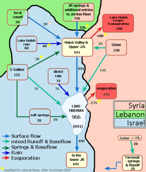
In the uppermost Jordan River basin, the 570 mcm/yr of natural source flows generated by Hasbani, Banias, and Liddan join together to form what is known as the upper Jordan River, i.e., the river from the sources down to Lake Tiberias (Sea of Galilee or Lake Kineret in Hebrew). Along the course of the upper Jordan River, the Golan Heights issue another 230 mcm/yr from springs, rivers, and as surface runoff. Small amounts of additional inflows also emerge from the western side, what is today northern Israel. All in all, under natural conditions and before human abstractions, the total average inflows into Lake Tiberias – from the Jordan River, the Golan runoff, direct rainfall over the lake, and local hot springs – can be estimated at 966 mcm/yr, of which some 275 mcm/yr were lost to natural evaporation from the lake’s surface.
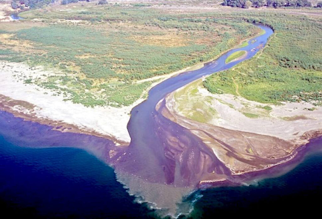
The remaining 691 mcm/yr of natural flows used to run out of the lake and formed the lower Jordan River that ran mostly in the Jordan Valley (Al-Ghor) between the East and the West Bank and ended at the Dead Sea.
The lower Jordan River is joined by the Yarmouk River from the east, which for the most part forms the border between Syria and Jordan, and contributes around 500 mcm/yr. Finally, the side wadis and springs on the East and West Bank add to the total Jordan River flows.
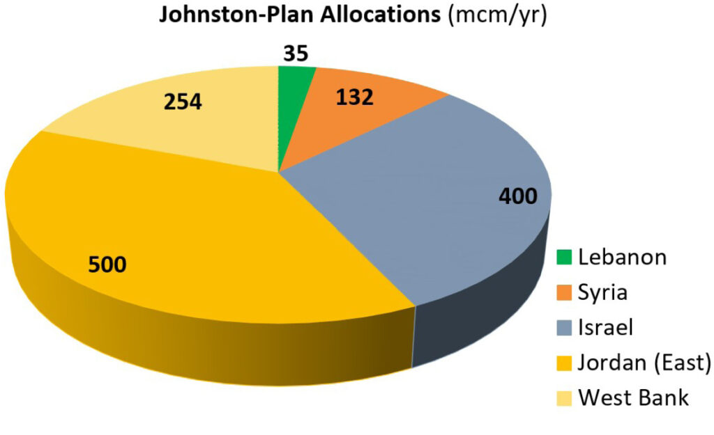
Thus, for historic times before human abstractions, the natural flow of the entire Jordan and Yarmouk River flow system from the springs to the Dead Sea has been estimated at 1,736 mcm/yr. However, most texts from the British Mandate period and soon after the Nakba accounted for a somewhat diminished river flow system, already under some human consumption. Hence, the important and most-quoted sources, such as the 1955 Johnston Plan, ranged the flows of the Jordan River at around 1,400 mcm/yr. Groundwater inflow contributions, unlike the examples above, were counted at the spring location (i.e., where groundwater emerged, not where it was generated). Lebanese contributions were considered to account for 8.6 percent, 31.1 percent were interpreted as “Israeli” contributions, 11.4 percent were Syrian contributions, and the rest, almost 50 percent, were contributions from Jordan (which back then also included the West Bank as part of the Hashemite Kingdom).*3 In other words, the Jordan River at that time was largely a Jordanian river.*4
Let us now turn our attention to the state of human abstractions and their relative shares from the Jordan River waters.
The Johnston Plan suggested the following distribution of allocation and benefits from the Jordan River: only 2.5 percent for Lebanon and 10 percent for Syria, which is quite unfair considering their flow contributions.*5 By contrast, Israel was favored and allocated almost a third of all flows, the argument being that it was a victim of geography and that its fate, if not its sheer existence, depended on high shares. Jordan at the time had just taken over the West Bank and integrated it into its state territory. It carried the main burden of receiving the violently expulsed Palestinian refugees. The US-backed Johnston Plan attempted to quell and stabilize this aftermath of the Nakba by promising Jordan rich shares of over 750 mcm/yr from the Jordan River, not only to boost its economy but also to settle and pacify the masses of homeless Palestinian refugees. Large irrigation schemes were envisioned and promised under the Johnston Plan, both for Jordan (East Bank) and for the West Bank (which was allocated 254 mcm/yr, roughly one-third of the Jordanian shares).*6
The Johnston Plan was never ratified by the concerned states, and instead, Israel pushed ahead with its unilateral abstraction schemes, most important of which is the so-called National Water Carrier (NWC), which pumps vast amounts of freshwater out of Lake Tiberias,vii transfers it from the Jordan River Basin, and uses this water to supply its coastal cities and “make the desert bloom” – a euphemism for the ongoing campaign of Judaizing the Negev and ethnically cleansing the local Bedouin population. As soon as the NWC was in place (1964) and fully operational (1970), the face of the entire lower Jordan River and the Dead Sea changed dramatically and beyond recognition.
Israel’s understanding of hydro-justice (equitable allocations) is an extreme example of pure and unfettered hydro-egoism according to the motto: What’s mine is mine, what’s yours is … mine, too! Hence, we see the following situation on the Jordan River course.
At Alumot-Dam, the former outlet of Lake Tiberias has been turned into smelly dead water. 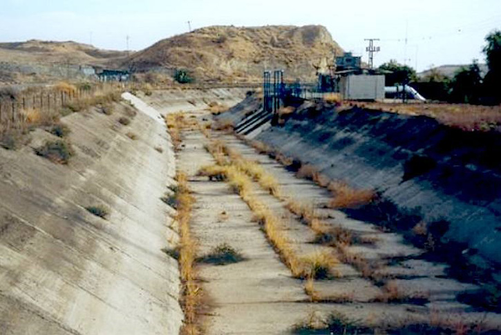
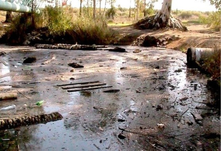
Five kilometers downstream, the “river” then looks like this for most of the year.
Syria: The main contributor to the upper Jordan River, Syria receives not a single drop of its flows, since the Golan was militarily occupied and illegally annexed by Israel.
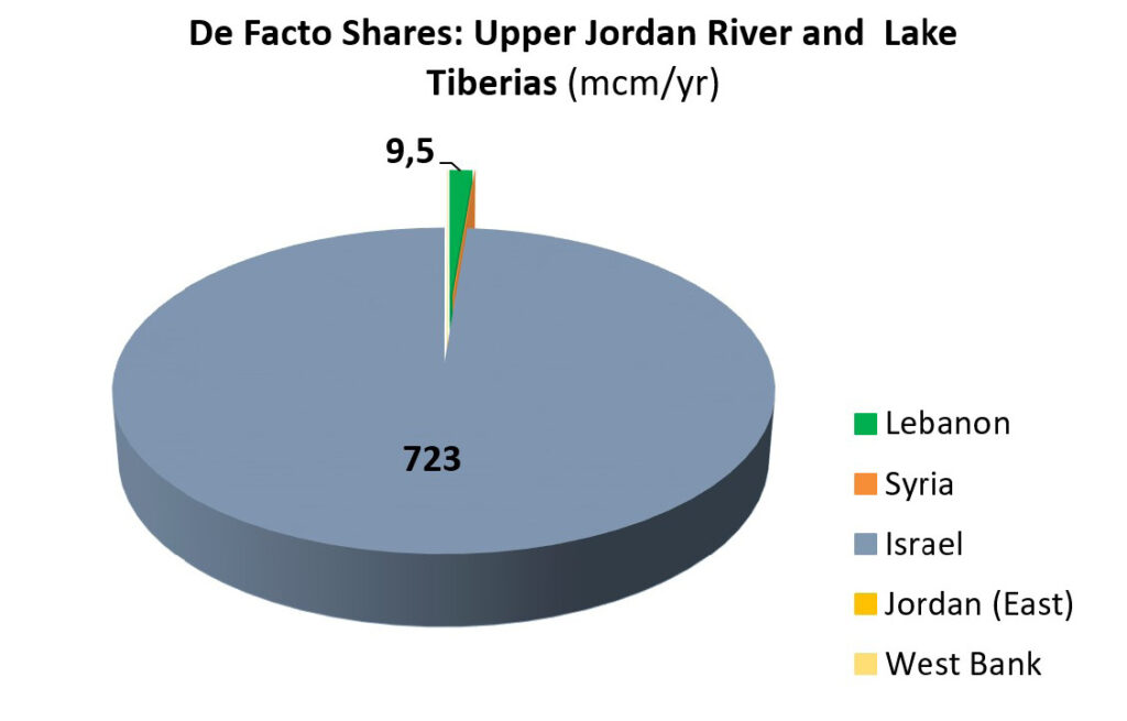
Lebanon: This spring-source state receives a minimal share of only 9.5 mcm/yr, far below the even modest allocations under the Johnston Plan! In 2003, when Lebanon tried to install a few small pumps for an additional 10 mcm/yr, then Prime Minister Sharon immediately and openly threatened war – a threat that Lebanon had to take seriously after decades of Israeli occupation. This warmongering did the trick, and Israel made sure that the upstream riparian does not dry up its lower-end riparian neighbors.
The de facto annual abstractions of the upper Jordan River are a stark illustration of this deeply entrenched hydro-injustice – 9.5 mcm for Lebanon, 723 mcm for Israel, nothing for Syria.
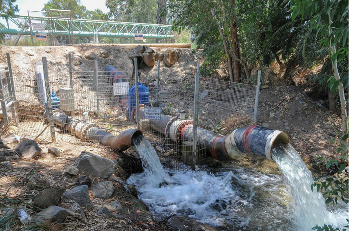
But what a contrast to Israel’s own behavior towards the lower-end riparians, Jordan and the occupied West Bank! At Lake Tiberias, Israel pumps literally every single drop it can abstract from the river. What was once a rapidly flowing, fresh, and important regional river of 772 mcm/yr of natural outflows at Lake Tiberias has diminished to a trickle of less than 10 mcm/yr, in some years even as low as 0.3 mcm/yr.*8 A few kilometers south of the lake, the lower Jordan River for most of the year is simply a dry riverbed. Israel allows only some hypersaline diversion flows and wastewater outflows – until a few years ago, untreated – to reach the lower Jordan River.
The poor trickle that today still reaches the Dead Sea does not stem from its original source, the upper Jordan River but almost exclusively from the side tributary, the Syrian-Jordanian Yarmouk River. Syria, which gets not a drop from the Jordan, abstracts large amounts of groundwater (springs and wells) in its Yarmouk basin, which together amounts to an estimated 500mcm/yr.
Jordan: The second biggest loser is the Hashemite Kingdom of Jordan, which suffers not only from a totally dried up Jordan River but also from the consequences of signing a very unfavorable peace deal with Israel in 1994. The conditions of this deal are one of the reasons why this peace agreement is so popular in Israel and so deeply unpopular among the Jordanian population.
If we compare the Johnston Plan with the outcome of the peace agreement, the poor negotiation result becomes visible. Jordan simply gave up any and all shares of the fresh Jordan River, i.e., the flows in the upper Jordan River that should reach down to the Jordanian downstream positions but which are in fact fully intercepted by Israel. It sanctioned and thus “legalized” this, which cannot be reconciled with international water law: Unlimited use of water from the Jordan River for Israel (see table below).
Table: Comparison of Water Allocation in mcm/yr according to the Johnston Plan and the Jordan-Israel Peace Agreement 1994 (Lebanon-Syria-Israel-Jordan-Palestine)
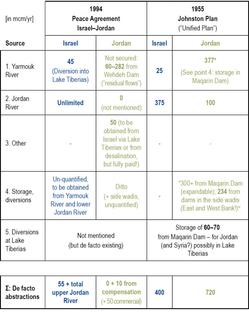
If we take the Jordan River allocations as a metaphor, then the state that is named after a once-existing river called Jordan should be renamed the Hashemite Kingdom of Yarmouk (“residual flows”).
Palestine: Finally, we come to, of course, the biggest loser of all. Palestinians before the occupation used to simply hang their pumps in the river to irrigate their fields in the Jordan Valley of the West Bank (Al-Ghor). The amount they used is estimated at around 90 mcm/yr. Their Jordan River allocation according to the Johnston Plan would have been 254 mcm/yr (the accumulated amount since 1967 would be 13,462 mcm, in other words, 13 billion cubic meters). The Palestinian actual share since 1967 can be precisely determined: zero-point-zero-zero drops in 53 years. Most Palestinians have not even seen with their own eyes the sorry remainders of the lower Jordan River. It lies out of reach beyond a heavily guarded, military cordon sanitaire, erected by Israel as early as June 1967 – if you will, Israel’s first annexation of the Jordan Valley, to be completed now under the guidance of Trump & Co. (and lamented but not prevented by the rest of the world).
The threat of Israeli violent military annexation cannot reduce Palestinian abstractions from the river itself – they are already zero (and the lower Jordan River was long ago made to disappear by Israel). Together with the two-state “solution,” it would bury all hopes for even the most modest Palestinian share in the river. Yet, the loss of the Jordan Valley would bereave Palestinians of all prospects to finally enjoy the fruits of one of their largest and last remaining potential sources of indispensable groundwater supplies. But this is another story of another crime.
*1 Phillips et al. (2007), www.researchgate.net/publication/245327845_The_Jordan_River_Basin_1_Clarification_of_the_Allocations_in_the_Johnston_Plan.
*2 See www.water-alternatives.org/index.php/alldoc/articles/vol8/v8issue2/290-a8-2-13/file?auid=69.
*3 A breakdown of these “Jordanian” contributions would result in 11.1 percent stemming from the oPt (West Bank) and 37.9 percent from Jordan (East Bank).
*4 Phillips et al (2007b: 49), www.tandfonline.com/doi/abs/10.1080/02508060708691964.
*5 But Johnston argued that Lebanon, in particular, was blessed with ample additional sources of water from its high mountains.
*6 See Clemens Messerschmid, “False Promises for Gaza,” TWiP, July 2018, available at www.thisweekinpalestine.com/false-promises-gaza/.
*7 In addition to over 200 mcm/yr of Israeli river abstractions between the source springs and the lake (HSI, 2012: 18), www.water.gov.il/Hebrew/about-reshut-hamaim/The-Authority/FilesWatermanagement/water-report-MEDITERRANEAN-SEA-AND-THE-JORDAN.pdf).
*8 In 1995/96, according to official records by the Hydrological Service of Israel (HSI, 2016: 449; Ch. 9: “כינרת אגם” Lake Tiberias). Only a few days a year, when strong winter rains pour down from the Syrian Golan, does Israel allow freshwater outflows into the lower Jordan River, http://water.gov.il/Hebrew/ProfessionalInfoAndData/Data-Hidrologeime/2014/yamat-kinneret-2014.pdf.
ix Opened in 2011, Wehdeh Dam was built at the Yarmouk River on the border between Syria and Jordan. It was supposed to be the main water reward for Jordan under the 1994 Peace Agreement with Israel – that is, Israel generously allowed Jordan to build this dam after having bombed the construction sites for the so-called Maqarin Dam (envisioned already by the Johnston Plan) several times during the previous decades. However, the Wehdeh (“unity”) Dam of the new-found unity with Israel miserably failed to deliver. The average yearly runoff volume was supposed to reach 200 mcm – in reality, only 0.2 mcm were recorded in most years, and in exceptionally wet years, up to 2 mcm or at best 1 percent of the hoped-for quantities; www.bgr.bund.de/EN/Themen/Wasser/Projekte/laufend/TZ/Jordanien/wateryearbook2016-2017.pdf?__blob=publicationFile&v=2 (p. 30).